

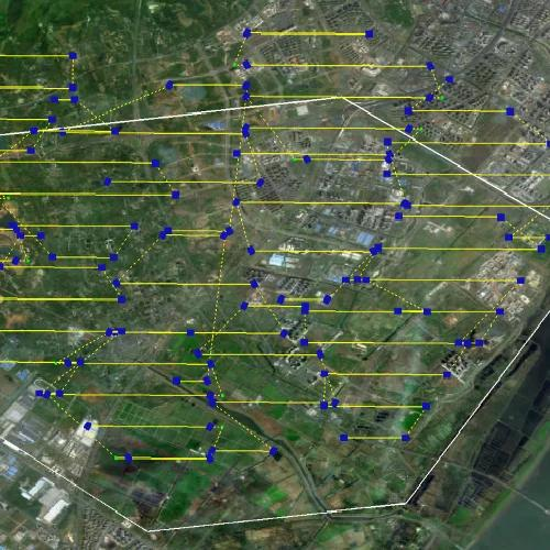
Multi-UAV operations are moving beyond simple parallel flights. In surveying, infrastructure inspection, and emergency response, several aircraft may need to divide an area, avoid overlapping routes, and adapt when conditions change. Multi-UAV path planning addresses these requirements by coordinating flight routes across multiple aircraft, making path planning a system-level problem rather than simply assigning independent waypoints.
For engineering teams evaluating a multi-UAV solution, the key question is not simply which algorithm produces the shortest route. A practical system must balance coverage, flight time, energy use, obstacle constraints, communication conditions, positioning accuracy, and the ability to re-plan when a mission changes. Research on multi-UAV path planning commonly covers classical, heuristic, metaheuristic, machine-learning, and hybrid approaches, with real-time coordination and scalability remaining important considerations.
How Multi-UAV Path Planning Algorithms Work
A multi-UAV path planner normally starts by representing the operating environment, mission objectives, and aircraft constraints. The system then assigns tasks and calculates routes for individual UAVs while considering the behavior of the overall swarm.
Classical methods can be effective when operating conditions are well defined. Heuristic and metaheuristic approaches can search larger solution spaces and optimize multiple objectives. Hybrid approaches combine different techniques to improve practical performance.
For deployment, algorithm selection should therefore be connected to the actual mission. A route that is mathematically short may not be operationally efficient if it creates excessive overlap, increases energy consumption, weakens communication links, or leaves important areas uncovered. Real-world systems also need to respond when obstacles, weather, positioning conditions, or mission priorities change.
What Determines Real-World Multi-UAV Performance
The first factor is task allocation. A swarm needs to determine which UAV should cover which area or handle which task. Intelligent zoning can reduce redundant flight paths and make better use of different UAV capabilities, especially across large or irregular survey areas.
The second factor is route coordination. UAVs must operate as a coordinated group rather than as isolated aircraft. Effective coordination can involve speed, altitude, coverage density, and flight-path management. Dynamic re-planning is particularly valuable when an aircraft encounters an unexpected condition or when mission priorities change.
The third factor is positioning. Path planning depends on accurate spatial information. Reliable positioning helps the system determine where each UAV is operating and whether planned coverage is being achieved. Communication is another consideration because routes may need to account for intermittent connections or limited bandwidth.
This is where edge processing can influence the overall system architecture. Instead of sending every raw image to a remote processing center, drone edge computing can process information closer to the point of collection. This approach can reduce the volume of data that needs to be transmitted and support faster access to processed results.
Connecting Path Planning With Real-Time Drone Data
Path planning should not be evaluated separately from mapping and spatial analysis. If route generation and data processing are disconnected, operators may still face delays after flight execution.
The DroneSwarm Real-Time Onboard Analysis System from Icecypress Technology is designed around an integrated approach. According to its official product information, the system supports multi-UAV collaborative real-time 2D and 3D reconstruction, target recognition, positioning, tracking, unified command, and onboard edge processing.
Its multi-UAV path-planning functions use UAV performance and environmental perception to generate flight paths and dynamically optimize speed, altitude, and coverage density. The system also supports runtime task re-planning and swarm dynamic regrouping. For surveying and mapping, intelligent zoning considers terrain and UAV capabilities, while route-overlap optimization is intended to improve coverage efficiency.
The product information also describes real-time orthophoto generation during flight, embedded global bundle adjustment, and communication optimization that transmits processed results rather than raw imagery. According to the official product page, the communication load can be reduced to only 1% of conventional workflows. For 3D reconstruction, distributed parallel computing and onboard processing are designed to support large-scale modeling within 10 minutes after the mission ends.
Evaluating Performance Beyond Route Length
A procurement team should assess more than the theoretical quality of an algorithm. Useful criteria include route efficiency, coverage completeness, collision avoidance, computational cost, re-planning time, positioning performance, communication requirements, and scalability as the number of UAVs increases.
Performance also depends on what happens when connectivity becomes unreliable. DroneSwarm supports online and offline operation, with cached imagery available when communication is interrupted. Its product documentation states that GPS and visual SLAM are combined for real-time positioning, with positioning accuracy specified as less than 1×GSD.
The system also provides automated comparison of multi-temporal DOM and 3D models. The official product page specifies pixel-level change-detection accuracy above 95%. These capabilities are relevant when UAV missions are used not only to collect imagery but also to support subsequent spatial analysis and monitoring.
This illustrates why path planning is only one part of a broader operational workflow. A planner that cannot support positioning, data processing, or mission updates may create bottlenecks elsewhere in the system.
Where Multi-UAV Path Planning Creates Practical Value
For government authorities and industrial organizations, the evaluation should focus on practical requirements such as area size, UAV types, terrain, positioning, communication, data outputs, and response time. The selected system should be assessed against measurable operational goals.
The role of drone edge computing is closely connected to this workflow. By processing data closer to the point of collection, it can support faster coordination, mapping, reconstruction, and spatial analysis. For professional buyers, the priority is not simply shorter flight paths, but a multi-UAV system that can coordinate operations, adapt to changing conditions, and deliver usable geospatial data efficiently.
