

Autonomous machines and modern mapping platforms depend on more than basic location awareness. Their performance often depends on knowing exactly where a vehicle, measurement point, or collected dataset sits within a geographic reference. RTK GPS precision becomes particularly valuable when ordinary positioning is not sufficient for repeatable navigation, surveying, inspection, or spatial data collection.
The practical question, therefore, is not simply whether RTK can provide accurate coordinates. It is where that precision directly improves an autonomous or geospatial workflow.
Autonomous Navigation Starts With Reliable Positioning
Autonomous equipment needs a stable position estimate to understand its relationship with routes, boundaries, targets, and previously recorded locations. Agricultural machinery, mobile robots, construction equipment, and other autonomous platforms can use precise satellite positioning as one input for navigation and motion control.
A conventional GNSS position may provide useful location information, but applications requiring repeatable paths or precise waypoints demand greater positional confidence. An RTK receiver can supply corrected positioning data that becomes an input to the vehicle’s broader localization architecture.
Positioning alone does not make a machine autonomous. Cameras, LiDAR, inertial sensors, wheel measurements, and control software may also contribute to localization. RTK is most useful when its geographic reference complements those other sensing methods and helps the system maintain a consistent understanding of its position.
Geospatial Mapping Needs a Precise Spatial Reference
Mapping is another major area where precise satellite positioning has a direct operational role. Surveyors and mapping teams collect information from physical locations, but measurements from cameras, laser systems, or other sensors must ultimately be associated with geographic coordinates.
RTK GPS precision can provide that spatial reference for land surveying, construction measurement, GIS data collection, and other geospatial tasks. The AL16, for example, is specified for land surveying and mapping, construction and engineering measurement, and GIS data collection. Its published RTK performance is based on defined measurement conditions rather than a general claim of universal accuracy.
That distinction matters for professional users. A precise coordinate is valuable because it gives separately collected observations a consistent geographic relationship. This can make field data easier to integrate into engineering, surveying, inspection, and digital mapping workflows.
Inspection And Survey Work Benefit From Non-Contact Positioning
Certain measurement environments make conventional surveying techniques inconvenient. Obstructions, restricted access, uneven terrain, or structures that cannot be approached directly can complicate the collection of accurate field points.
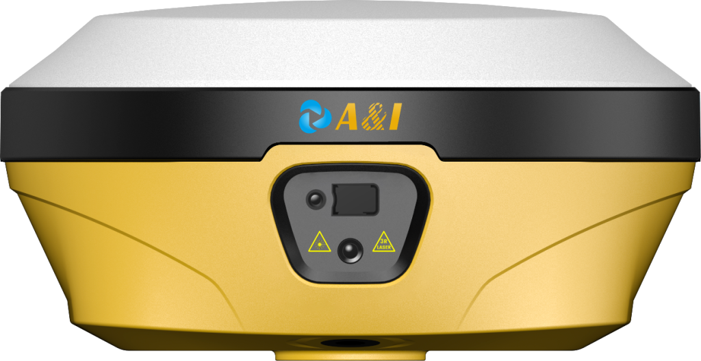
The AL16 combines RTK GNSS with an IMU, laser measurement, and a 13-megapixel camera. Its product documentation states that the system is designed for highly accurate non-contact measurements in environments with obstructions and difficult-to-reach areas. The laser and camera combination can therefore extend precise measurement beyond situations where a traditional centering pole is practical.
Infrastructure and utility inspection represents another relevant application. Positioning can associate observed assets or measurement results with their physical locations, creating a more useful geographic record for subsequent analysis or field work. The value comes from connecting measurement with location rather than treating coordinates as an isolated output.
Drone Workflows Extend Precise Positioning Beyond The Ground
Aerial platforms introduce another positioning requirement because cameras and other payloads collect information while the aircraft is moving. Accurate geographic positioning can support ground control activities, calibration, and the organization of captured spatial data.
The AL16 specifically lists drone ground control and calibration among its applications. Its connectivity options include cellular, Wi-Fi, Bluetooth, NFC, and an integrated radio system, giving deployment teams several communication pathways depending on the operating setup.
For mapping teams, the important relationship is between the aerial platform and its geographic reference. Better positioning can help establish where observations were made, while the mapping software and payload determine how those observations are processed into a final dataset.
Integration Determines How Positioning Performs In The Field
Real-world positioning systems rarely operate as isolated GNSS units. A professional deployment may combine satellite signals with inertial measurements, laser observations, cameras, correction data, and communication links.
The AL16 illustrates this integrated model through its laser measurement, IMU-based tilt measurement, camera-assisted targeting, and RTK GNSS functions. Its documentation also specifies RTCM 3.x support for differential corrections and multiple communication interfaces.
Archimedes Innovation positions the AL16 as a laser RTK GNSS receiver for applications spanning surveying, engineering measurement, agriculture, GIS collection, infrastructure inspection, and drone-related workflows. That range demonstrates how the same positioning principle can serve very different systems when the surrounding sensors and interfaces are selected for the application.
Archimedes Innovation also emphasizes compact integration, combining positioning, measurement, imaging, and connectivity within one field-oriented device. For system designers, this can matter when equipment size, operator workflow, communications, and sensor coordination are as important as coordinate accuracy.
The Application Defines The Required Level Of Precision
RTK GPS precision has the greatest practical value when positional error can affect an operational result. Autonomous machines may need dependable coordinates for route execution, while surveyors need accurately located measurements. Inspection teams may need to associate observations with physical assets, and drone workflows may require a reliable geographic reference for aerial operations.
This application-led method is shown by Archimedes Innovation‘s AL16, which combines RTK GNSS, inertial measurement, imaging, laser measurement, and field connectivity. Its mentioned applications demonstrate how such capabilities transfer into real operations, while its standards specify RTK horizontal and vertical performance under stated situations.
The purpose of the evaluation of accurate positioning should guide the evaluation process. When reliable geographic information is required for autonomous navigation, precise surveying, measurement in hard-to-reach areas, collecting of geographic information systems data, inspection of infrastructure, or ground control of drones, RTK stops being only a positioning capability. Part of the larger system, it becomes essential.
